Wheat Product Selection and Placement for the Northern Plains
February 14, 2024
- In addition to yield, farmers consider several performance characteristics including grain protein, straw strength, height, maturity, and disease tolerance when selecting a wheat product.
- Wheat products should be selected to perform in the landscape and climate of each Northern Plains region.
- Having multiple products with different strengths helps reduce the risk of individual weather events and harvest times impacting the entire crop.
Product Selection for Risk Management
Northern Plains wheat classes include hard red winter and hard red spring wheat, with hard white spring wheat making up a very small additional annual acreage. Each class has characteristics that help make it successful in different parts of the Northern Plains geography (Figure 1). Within the wheat class grown, farmers should select multiple products with a range of agronomic characteristics to match the growing environment and risks of their particular fields (Tables 1 to 4).
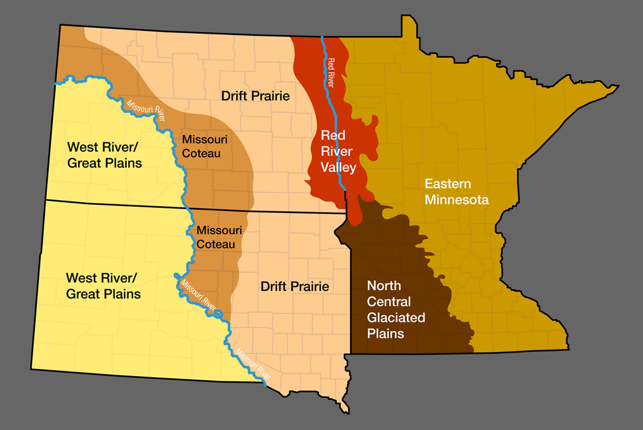
Geographies
Red River Valley – This area extends along the entire Minnesota/North Dakota border, about 25 to 40 miles east/west of the Red River of the North into Minnesota and North Dakota, respectively. The Red River Valley is not a typical river valley as it was once the floor of the enormous, glacial Lake Agassiz which deposited rich glacial till and lake sediment along the valley. Soils in this region are characterized by high clay content (about 30 to 60%), high silt content, very little sand content, high organic matter, and a generally black color in the thick A horizon.
Total precipitation in this region averages between 16 to 23 inches per year. Most of the precipitation occurs as rainfall, though some accumulates as snowfall due to the continental climate. Winter wheat planting occurs throughout September, with earlier planting dates in northern areas. Spring wheat is typically planted between April 15 and May 15 in this region, or as early as the soil is trafficable after snowmelt.
The most important wheat diseases in this region are fusarium head blight, yellow rust, common rust, and bacterial leaf streak. Spring wheat is the dominant wheat class in the Red River Valley.
Drift Prairie – The drift prairie is a large region in the Northern Plains encompassing land in both North Dakota and Minnesota. The eastern boundary of the Drift Prairie is the Red River Valley in North Dakota in what is called the beach ridge of Lake Agassiz. The eastern boundary continues south along most of the South Dakota border. The western boundary falls near the continental divide as it separates drainage to the east and west in North Dakota and South Dakota. The Drift Prairie covers the northeast portions of Divide, Burke, Ward, Sheridan, and Wells counties, the eastern half of Stutsman County, the western border of Lamoure and Dickey counties in North Dakota, and most of the eastern 1/3 of South Dakota.
The Drift Prairie was formed by repeated glaciation which resulted in rocky glacial sediment deposits, also known as drift. The glacial melt caused the distinct low hills and small, deep lakes that give the Drift Prairie its other name, the Prairie Pothole Region. Production in this zone is predominantly conventional tillage but transitions to no-till toward the western fringes of the region. Soils also become more variable in the western areas of the region, with more equal parts silt, sand, and clay, and with lower organic matter than the Red River Valley.
Plantings in this region are predominantly spring wheat in North Dakota, transitioning to a more 50:50 spring wheat and winter wheat mix in the South Dakota Drift Prairie. The most important diseases throughout the Drift Prairie are common rust, tan spot, Septoria leaf blotch, fusarium head blight (especially in the northern Drift Prairie) and yellow rust (common in the southern portion).
Missouri Coteau – The Missouri Coteau is a large, high-elevation plateau that extends east of the Missouri River and west of the Drift Prairie and continental divide. From North Dakota, the Missouri Coteau drops down into North Central South Dakota. This region had many continental glaciations and is thus characterized as hilly and poorly drained. The soils of this region are sandy loam to loamy, with soil organic matter averaging between one and three percent.
The region has an average of 12 to 18 inches of annual precipitation, mostly as rainfall. Within the Missouri Coteau lies a general dividing line between cool and moist conditions to the north and east and warmer and drier conditions to the south and west. However, the exact location of this line varies yearly.
Spring wheat is the primary crop in the region for North Dakota, though consistent winter wheat production is also found, albeit on a smaller acreage than spring wheat. Plantings in South Dakota are a variable mix of winter and spring wheat. This region predominantly uses no-till or reduced tillage production, and farmers maintain diverse crop rotations throughout the region.
West River/Great Plains – This hilly region in South Dakota is referred to as the West River or Great Plains and extends to the east of the Missouri River to the Drift Prairie. The terrain west of the Missouri River in North Dakota and South Dakota becomes more arid and rugged. It includes the tallest points in North and South Dakota, White Butte and Black Elk Peak, respectively, and the Badlands geographic formations of both states. Soils in this region are much older than those found in eastern North Dakota and South Dakota, as glacial events never impacted the West River/Great Plains area. There is also much less rainfall due to the rain shadow of the Rocky Mountains, with annual totals ranging between 8 to 14 inches per year and the stark possibility of significantly lower precipitation.
Crop production moves more to a continuous wheat rotation under strict no-tillage production practices to conserve soil moisture. Spring wheat is predominant in the North Dakota West River region, although considerable interest in winter wheat is present in some years. In South Dakota, this region is primarily and consistently used for winter wheat production, with spring wheat being a more minor crop. Depending on the crop rotation, winter wheat planting occurs from September 15 to October 15. Disease prevalence in the West River region shifts towards no-till and southern diseases, where tan spot, Septoria blotch, and wheat streak mosaic virus predominate and leaf rusts develop occasionally. Wheat stem sawfly is more of a concern in this area than it is in the rest of the Northern Plains.
Eastern Minnesota – The largest and most geographically diverse region within the Northern Plains, this region lies east of the clay-predominated soils of the Red River Valley in Minnesota and the North Central Glaciated Plains. It contains a soil gradient from the western to the eastern portions of this region, as well as from the north to the south, and consists of several eco-regions grouped into one. Productive agricultural soils intermix with non-producing acres of poorly drained, rocky, and wooded ground varying from broadleaf to conifer forest. Soils in this region range from nearly 100% sand in the topsoil to clay and are generally described as diverse. The northern reaches of this region are a mix of the coolest temperatures and highest precipitation in the Northern Plains, which combine to make it a highly productive wheat-producing region.
Due to the lower growing-season temperatures experienced in the northern parts of this region, spring wheat flourishes with extensive tillers, high biomass accumulation, and high yields. Average temperatures are higher in the south of this region while moisture remains similar, and wheat acreage drops off dramatically. Rainfall in this region is typically the highest of the Northern Plains, ranging from about 15 to 25 inches, with an average at 20 to 22 inches per year. The primary diseases in this region are fusarium head blight in the north, with bacterial leaf streak, crown and foot rots, and tan spot reducing yields on a smaller scale across most of this region.
North Central Glaciated Plains – This region is located to the east and south of the Red River Valley in Minnesota and east of the Drift Prairie in South Dakota. It is both south and west of the broad Eastern Minnesota region. Soils are diverse throughout, and may be rolling to level, ranging from clay-loam to sandy-loam. The crop rotation in this region has moved toward a soybean and corn rotation, though spring wheat remains consistent in the region on smaller acres than row crops. Spring wheat is planted quite early, as early as April 1 or even into March in some years. The earlier plantings help offset the heat that comes with the southern latitude in this region, which tends to limit yield potential. Rainfall is plentiful in the North Central Glaciated Plains, ranging from 16 to 26 inches. Southern wheat diseases tend to be more prominent, particularly yellow rust, which is found most years. Fusarium head blight, common rust, and tan spot are usually minor and less frequent diseases.
Northern Plains General Comments – The Northern Plains continues to support wheat production with its rich agricultural environment. North Dakota grows most of the spring wheat acres, while in 2022 Minnesota and South Dakota had a combined average planting of 2 million acres of spring wheat.1,2,3 South Dakota consistently grows most of the winter wheat in the Northern Plains.3 Different stresses and diverse agronomic practices affect the success of spring and winter wheat across the Northern Plains.
Table 1. Northern Plains Spring Wheat-Growing Regions.
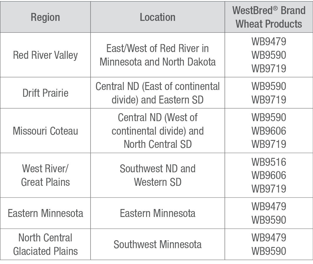
Table 2. Northern Plains Winter Wheat-Growing Regions.
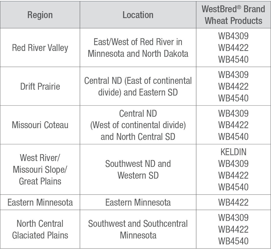
Table 3. Hard Red Spring Wheat Product Descriptions.
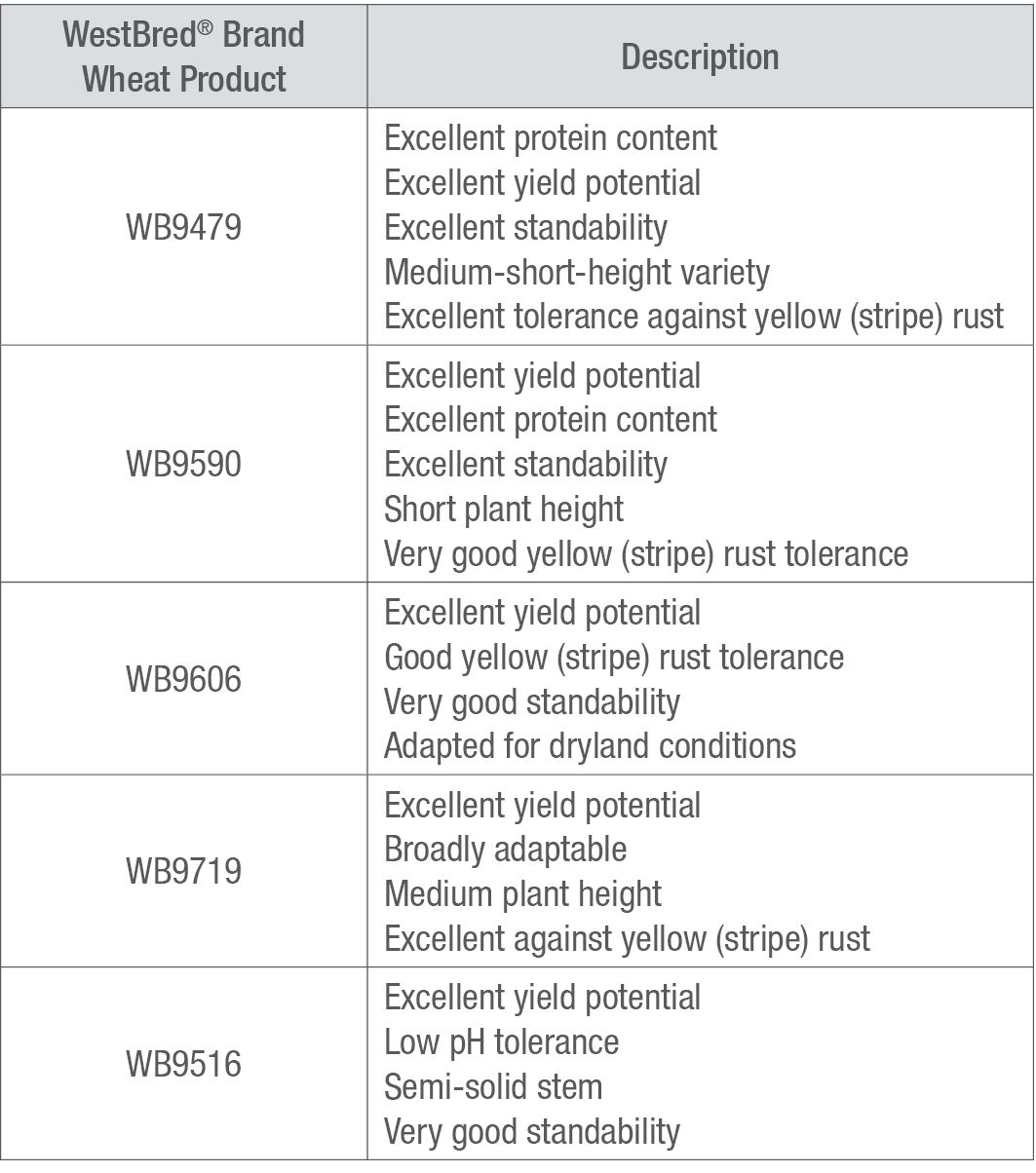
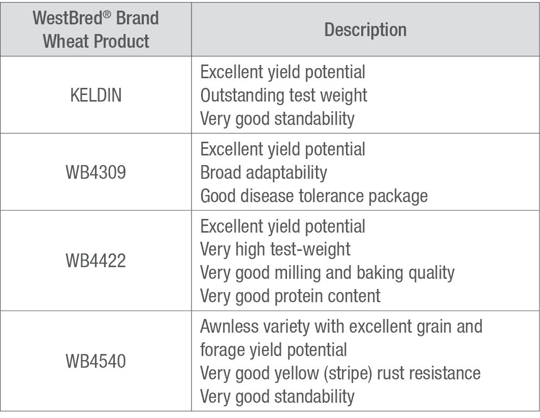
Table 4. Hard Red Winter Wheat Product Descriptions.
Sources
1USDA National Agricultural Statistical Service. 2024. 2022 State Agriculture Overview North Dakota. https://www.nass.usda.gov/Quick_Stats/Ag_Overview/stateOverview.php?state=NORTH%20DAKOTA
2USDA National Agricultural Statistical Service. 2024. 2022 State Agriculture Overview Minnesota. https://www.nass.usda.gov/Quick_Stats/Ag_Overview/stateOverview.php?state=MINNESOTA
3USDA National Agricultural Statistical Service. 2024. 2022 State Agriculture Overview South Dakota. https://www.nass.usda.gov/Quick_Stats/Ag_Overview/stateOverview.php?state=SOUTH%20DAKOTA
1710_359118